Fort Berthold Reservation Maps
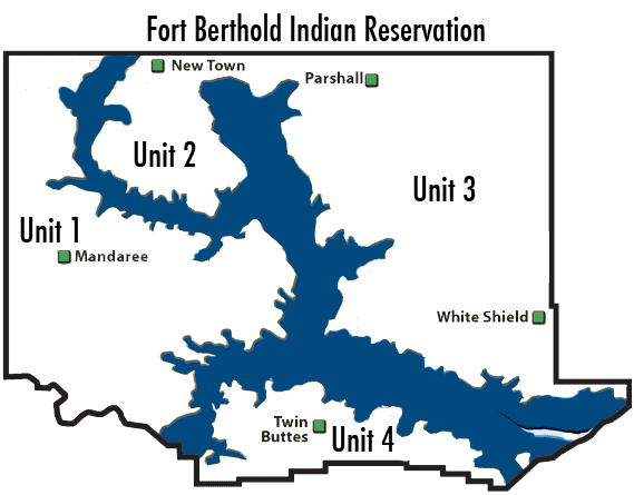
The Fort Berthold Indian Reservation presently consists of 988,000 acres of which 457,837 acres are owned by tribal members, either as allotted land or directly owned by the tribe. The Reservation is located on the Missouri River in McLean, Mountrail, Dunn, McKenzie, Mercer and Ward counties.
The Reservation is divided into four units: Unit 1, Unit 2, Unit 3 and Unit 4. Unit 1 is located west of Lake Sakakawea and is referred to as the Mandaree and Four Bears areas. It is our largest unit. Unit 2 is the Little Shell area and is located south of New Town. Unit 3 is located mainly on the east side of Lake Sakakawea and is commonly referred to as the Lucky Mound and White Shield areas. Lastly, Unit 4 is located south of Lake Sakakawea and is referred to as the Twin Buttes area.
Fort Berthold Reservation Maps
Fort Berthold Reservation Map 8.5in x 11in
Fort Berthold Reservation Map 11in x 17in
Unit 1 Maps
Four Bears Maps
Four Bears Map 8.5in x 11in
Mandaree Maps
Mandaree Map 8.5in x 11in
Unit 2 Maps
Little Shell Maps
Little Shell Map 8.5in x 11in
Unit 3 Maps
Lucky Mound Maps
Lucky Mound Map 8.5in x 11in
White Shield Maps
White Shield Map 8.5in x 11in
Unit 4 Maps
Twin Buttes
Twin Buttes Map 8.5in x 11in